
|
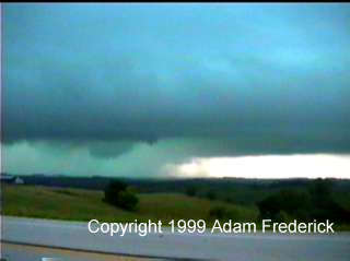
The set up for this day was almost exactly like May 30th 1998, one of my previous chases. There were two noticeable differences. The first was that everything was about 75 miles further south than May 30th, and the second was that South Dakota had a stronger cap. Already, at the beginning of the day there were severe storms. Quickly I left for Western Iowa to try and intercept this storm. As always, just before we caught up to the storm, the below warning was issued. This was the only tornado warning issued for this system that day. As we approached the storm, we ended up starting to see the structure around Kimballton Iowa. We ended up driving east out of Kimballton and saw a white stovepipe tornado out of the rear window. We got a chance to stop, and unfortunately it had gone back up into the air. We still saw the funnel as in the video capture below.
As we moved a bit further down the road, we were able to stop and see this funnel behind us.
To view more video captures from this storm, visit the 1999 video capture page in the Photo Gallery. |
|
DISCLAIMER: Remember storm chasing exposes
chasers to many hazardous and potentially deadly weather conditions such as
lightning, dangerous roads, damaging winds, hail, and flying debris which puts
the chaser's life at risk, particularly those who
have little or no experience and/or storm structure education. Learning to deal
with these is best done by understanding supercells and thunderstorms, and riding
with an experienced chaser before attempting to chase on their own. The author
of these pages does not encourage storm chasing and is therefore not responsible
for any actions as a result of what is seen here!
For questions or comments about this page, please visit our "Contact Us" page.
Created by Weather
Edge Inc. webmaster@severewx.com.
For your web design needs, please visit us at http://www.weatheredge.com
Content and Images (unless otherwise noted) Copyright 2000 Weather
Edge Inc. Images
and content may not be used without written consent. If you are interested in
the purchasing of pictures or video, please contact the webmaster.
Last updated 07/5/99 01:10 AM
 We
wanted to stay far away from this tornado since it was wrapped in very
large hail. According to some later reports, the hail in this storm
was three to four inches in diameter.
We
wanted to stay far away from this tornado since it was wrapped in very
large hail. According to some later reports, the hail in this storm
was three to four inches in diameter. 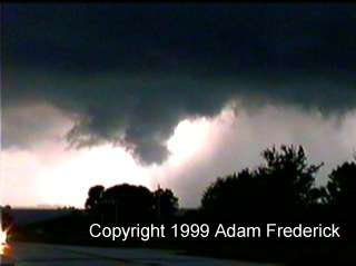 This
funnel was moving quickly toward us, so we had to relocate. Again, as
we were driving, we saw it touch town directly behind us. Since we were
driving, we were not able to get pictures of it. We eventually turned
south and went through Exira. Just south of Exira, we stopped to watch
the storm again. We ended up seeing a multiple vortex tornado just on
the other side of the hill. The bad news is that the contrast was not
the best so it is a bit hard to see in the video capture. It is the
wedge like formation just to the right of the stop sign.
This
funnel was moving quickly toward us, so we had to relocate. Again, as
we were driving, we saw it touch town directly behind us. Since we were
driving, we were not able to get pictures of it. We eventually turned
south and went through Exira. Just south of Exira, we stopped to watch
the storm again. We ended up seeing a multiple vortex tornado just on
the other side of the hill. The bad news is that the contrast was not
the best so it is a bit hard to see in the video capture. It is the
wedge like formation just to the right of the stop sign.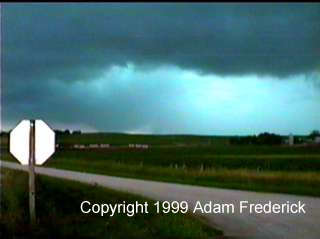 This lifted back into the air and as we drove away. I was able to get
this last picture of the storm.
This lifted back into the air and as we drove away. I was able to get
this last picture of the storm.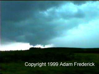 This storm started to get rain wrapped, so we abandoned the chase to
drive to South Dakota. Even though the cap was strong, there were surfaced
based CAPES of 7000 J/Kg and Helicity of 400 m^2/sec^2. If the cap could
break, another tornado as powerful as the Spencer South Dakota tornado
could have been possible. Fortunately for the residents of South Dakota,
no storms developed before sunset and there were no large tornadoes
after dark.
This storm started to get rain wrapped, so we abandoned the chase to
drive to South Dakota. Even though the cap was strong, there were surfaced
based CAPES of 7000 J/Kg and Helicity of 400 m^2/sec^2. If the cap could
break, another tornado as powerful as the Spencer South Dakota tornado
could have been possible. Fortunately for the residents of South Dakota,
no storms developed before sunset and there were no large tornadoes
after dark.