
|
This day was one of those strange days where there were large thunderstorms occurring already when I got up. As soon as I got up, I saw what the set up was like and I got my chase team together and quickly left. The storms were along and north of Highway 20 in Northern Iowa and were moving east. We decided to go north and catch them as they went along the highway. One of the supercells became a right mover and started moving toward the southeast. Once we learned this, we started making our way back south toward highway 30. There had been tornado warnings out on this storm now for about one hour. No major tornadoes were spotted even though it had strong shear and a hook echo on radar. As we were coming close to it, the warning below was issued. I didn't understand why just a severe T-storm warning was issued with this history of this storm. On the radar, it looked like there should have been a large tornado associated with the storm. We approached this storm with caution. As we drove west on Highway 30, all of a sudden the mesocyclone popped up out of nowhere. Since the skies consisted of mostly stratus clouds, it was not possible to see the mesocyclone until we were almost upon it. Since we were driving toward it, and it was moving toward us, we decided to move south to keep from getting hit with the 4" hail that it had been reported as producing. We dropped south out of State Center toward Rhodes. As we were doing so, the following warning was issued.
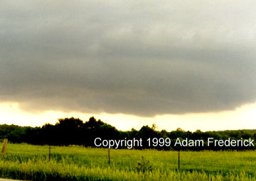
Now that we were on the southeast corner of the storm, we got a good look at it. This picture really does not do the storm justice.
We continued to move east following the storm. Because the storm was moving quite slow, the National Weather Service had to issue another tornado warning.
This supercell thunderstorm is what I would have termed a cyclic supercell. It kept strengthening and then weakening. Then once I thought it was dying, it would get another burst of energy, reorganize itself, and be back to full strength. Since it was so early in the day, I thought I had a storm to chase for the rest of the day. Once again the storm looked like it was weakening. Just when I thought it had died, it got one final burst of energy. It created the wall cloud and tornado below.
When it got this burst of energy, the National Weather Service issued a warning for the next county.
Then, just like in the movie "Twister," the storm died. Within five minutes after this wall cloud was recorded, the storm was gone from radar and sight. I looked up and saw blue skies overhead for the first time that day. All warnings were then canceled and the rest of the day in Iowa was calm. We had thought about heading back up to South Dakota for more storms later that day, but I thought that after seeing what we did, nothing would happen. I was wrong. Later that day is when the Spencer South Dakota tornado took place. For more pictures and video captures of this storm, visit the Photo Gallery page. |
||||
DISCLAIMER: Remember storm chasing exposes
chasers to many hazardous and potentially deadly weather conditions such as
lightning, dangerous roads, damaging winds, hail, and flying debris which puts
the chaser's life at risk, particularly those who
have little or no experience and/or storm structure education. Learning to deal
with these is best done by understanding supercells and thunderstorms, and riding
with an experienced chaser before attempting to chase on their own. The author
of these pages does not encourage storm chasing and is therefore not responsible
for any actions as a result of what is seen here!
For questions or comments about this page, please visit our "Contact Us" page.
Created by Weather
Edge Inc. webmaster@severewx.com.
For your web design needs, please visit us at http://www.weatheredge.com
Content and Images (unless otherwise noted) Copyright 2000 Weather
Edge Inc. Images
and content may not be used without written consent. If you are interested in
the purchasing of pictures or video, please contact the webmaster.
Last
updated 07/1/99 03:55 PM
 This
while section of the storm was rotating. The rotation was quicker than
what is normally seen in Iowa. It reminded me more of a storm in Nebraska
or Kansas. Because the storm was moving east now, the road grid allowed
us to run parallel to the storm. It dropped a few brief tornadoes as
seen in the video capture below.
This
while section of the storm was rotating. The rotation was quicker than
what is normally seen in Iowa. It reminded me more of a storm in Nebraska
or Kansas. Because the storm was moving east now, the road grid allowed
us to run parallel to the storm. It dropped a few brief tornadoes as
seen in the video capture below.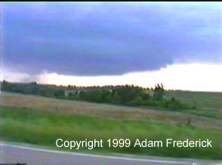 That
rain shaft on the left part of the screen was rotating and slowly moved
from left to right. It was only there for about 30 seconds. As we moved
through the city of Rhodes, there were people out in their yards looking
at the storm. There were even kids riding out of town on their mopeds
trying to get a look at it. It was a good thing this storm didn't produce
a tornado, otherwise someone would have probably been killed.
That
rain shaft on the left part of the screen was rotating and slowly moved
from left to right. It was only there for about 30 seconds. As we moved
through the city of Rhodes, there were people out in their yards looking
at the storm. There were even kids riding out of town on their mopeds
trying to get a look at it. It was a good thing this storm didn't produce
a tornado, otherwise someone would have probably been killed.